Friday, July 22, 2011

Why Use a Topo?

In an effort to make my own forest layers...
A topographic map is a map that depicts the features of a place ('Topo' greek for 'place') in a graphic way for the purpose of understanding more about that place. For ecological sciences, knowing where forests are is important information when trying to understand the ecology of a place.

Why use a pre-made Topo layer when you have access to many of the individual geographic features?
Have you seen a Topo map before. They are complex maps, with roads, names of places, natural features, and so on. It can be challenging to make Topo maps. Even if you have the all the data to to make a good Topo map, the companies that make Topos will still have information that I fail to have, I don't know where they get some of this stuff.

I've developed is forested regions. I was missing a crucial part of the landscape in Topo maps that I make--the Forest Layer.


'Pre-Made' Topo With Forest vs. My Topo Forest Layer:


I took satellite imagery, ran an Unsupervised classification (ISO cluster; Maximum Likelihood Classification), kept only the cells that were of a 'Forest' class. One thing I could do to improve this representation is to 'Generalize' the raster; to try to remove some of the 'Graininess/Pixelation'. Looks great on the map that I printed for our Black Footed Ferret Research Group. It makes a lot of sense when comparing it to the presence/absence layer of the Prairie Dog population too! Now to take this forest layer and compare it with of Pronghorn population data!
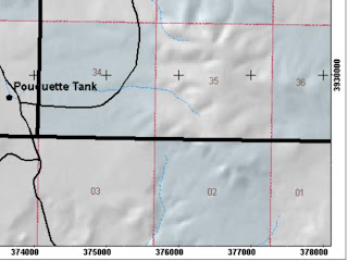
Grid: Data Frame Properties

One of the handiest techniques of making maps is placing a measured grid, in either lat/long or UTMs, on your map. Anyone with a GPS can figure out where they are on the map. Style preferences I follow include: Changing the 'Clip to Shape' as the current visible extent (while in layout mode), Change the label offset to 1 or 0, Change the size of the tic marks to 0 or 1, and place tic mark instead of lines inside the map.

Thursday, July 14, 2011

Sheep and Water Surveys in Game Management Unit 16A

I wouldn't wish my greatest enemy to do the surveys my partner Matt and I've been doing earlier this week. The purpose, however, is significant--determine the presence or absence of Big Horn Sheep in the Arrastra Mountain Wilderness, Game Management Unit 16A, by posting motion capturing cameras at developed and undeveloped springs.

The task was made more difficult due to the recent rains. Pools of water scattered through-out the wilderness and the weak flows in the springs made it impossible to determine a good location to post all but one camera--the terrain, too, potentially limited our ability to reach one of the springs.

Lessons were learned, with respect to understanding how to access difficult terrain in 'Wilderness'. Wilderness is a Department of Interior Statute with legal definition provided by the Wilderness Act of 1964. All mechanical forms of transportation are not allowed; therefore all roads since 1964 have been returning back to their natural state and are more difficult to find. So, to understand how to access this land it is best to research the designation and its borders from the either the National Park Service, Bureau of Land Management, Forest Service, Fish and Wild Life Service. Because I relied solely on my little understanding of the roads leading up to the wilderness boundary my partner and I started our hike straight through this rugged country--just a little more research would've made the quality of our work much easier and successful.

The hike was into Peoples Canyon. An interesting hiking designation, but can be extremely dangerous if not properly prepared. Bring topographic maps and a GPS unit--and know how to use them! This too was another lesson learned. We had the map and GPS; what we needed to do, before we left the truck, was to determine the coordinates of the trail head by referencing the maps UTM lines and using the GPS to position ourselves closer to that trail head. Thankfully, during this internship, I've learned how to place grids and graticules on a map for printing!